 L'hypercube
Future climate and adaptation
Studying future climate does not mean forecasting the weather on a specific day in 2080. Projections seek to determine how the statistical properties of climate may change: average temperature, very hot days, precipitation, droughts, winds, and extreme events.
They are essential for assessing the vulnerability of buildings, infrastructure, and urban spaces and for adapting projects to conditions unlike those observed today.
Climate projection and weather forecast
A weather forecast starts from the current state of the atmosphere and predicts its short-term evolution. A climate projection starts from assumptions about the long-term evolution of the climate system. It does not predict an exact sequence of days, but a climate statistically compatible with those assumptions.
Climate scenarios
Projections rely on possible pathways for climate forcings and socioeconomic change. Earlier generations used Representative Concentration Pathways (RCPs) such as RCP2.6, RCP4.5, and RCP8.5. More recent work uses Shared Socioeconomic Pathways (SSPs) associated with different levels of radiative forcing.
These scenarios are not forecasts: they explore possible futures and the climate’s sensitivity to emission pathways.
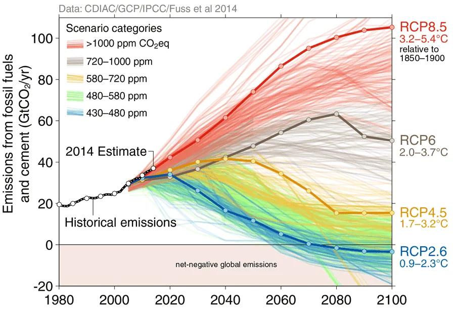
Source: Betting on negative emissions
Global Climate Models — GCMs
Global Climate Models represent the atmosphere, oceans, land surfaces, cryosphere, and their interactions at the planetary scale. Their resolution captures the major climate balances, but not always relief, coastlines, or regional phenomena in detail.
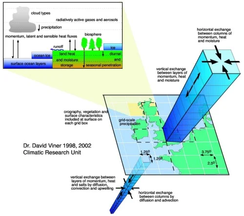
Source: IPCC
Regional Climate Models — RCMs
Regional Climate Models (RCMs) simulate a region at higher resolution using outputs from a global model as boundary conditions. They better represent relief, land–sea contrasts, regional weather, and spatial climate variability. Dynamic regionalisation can be complemented by bias correction or statistical downscaling.
CORDEX
CORDEX , the Coordinated Regional Climate Downscaling Experiment, is a World Climate Research Programme initiative that coordinates regional climate simulations and facilitates their comparison.
For Europe, EURO-CORDEX provides ensembles of simulations at a resolution of approximately 12 km for certain configurations. Combining several global and regional models makes it possible to study both average change and model-related dispersion. Reconstruction or temporal interpolation may still be required for hourly building simulations.
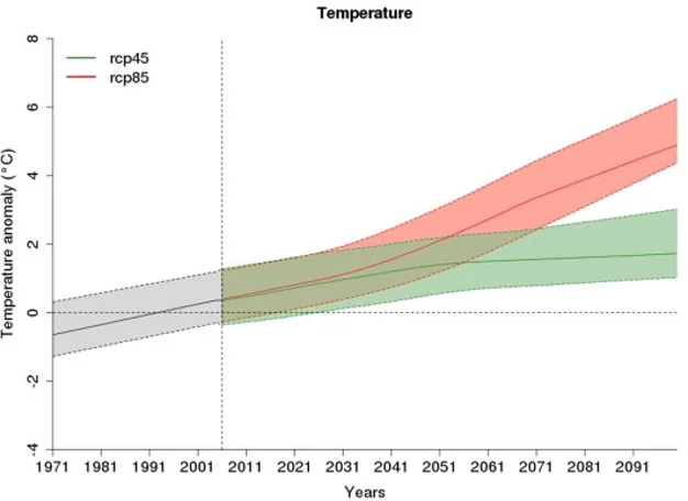
Source: Ouzeau et al.
DRIAS — Future climate
The DRIAS — Future climate portal distributes France’s reference regionalised climate projections for adaptation. It is operated by Météo-France with the French climate-science community.
Explore indicators
The Discovery area displays geolocated indicators—temperature, precipitation, hot days, or frost—depending on the available datasets.
Download data
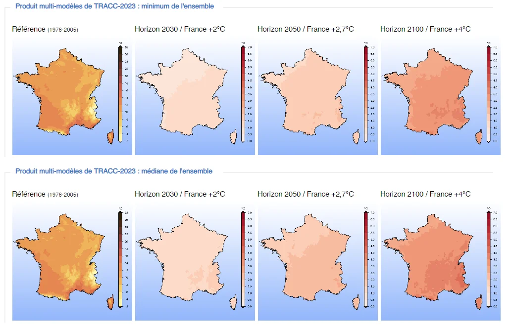
The Data and Products area provides variables and indicators for advanced processing. Reference products notably use a grid of approximately 8 km for mainland France. Recent products related to Explore2 and the TRACC supersede older datasets still cited in some historical documentation.
TRACC — a reference pathway for adaptation
The TRACC (Trajectoire de réchauffement de référence pour l’adaptation au changement climatique, or reference warming trajectory for climate-change adaptation) defines the climate for which France must prepare. Relative to the pre-industrial period, it sets the following levels for mainland France and Corsica:
- +2°C in 2030;
- +2.7°C in 2050;
- +4°C in 2100.
The 2100 level corresponds to approximately +3°C globally. The TRACC is neither a new model nor an additional scenario: it defines reference warming levels that regionalised projections translate into indicators for individual territories.
The trajectory was incorporated into the French Environmental Code by the decree of 23 January 2026. See the French Ministry for Ecological Transition’s pages presenting the TRACC and its regulatory incorporation .
From a global scenario to a project
Constructing future weather files
Climate projections often require transformation before they can be used in thermal or energy simulation software.
Future typical year
A future TMY represents average climate around a given horizon, for example using several decades centred on 2080. It can be used to study heating, cooling, comfort, natural ventilation, and energy consumption. Like a current-climate TMY, it tends to smooth out rare events.
Specific future years
Climate simulations also produce continuous series in which particularly hot years, dry summers, or severe heatwaves can be identified. Selection must account for models, scenarios, years, and intensity levels. Defining a target risk level or quantile is often more robust than automatically selecting the “worst year”.
What about future extreme events?
Adaptation cannot rely on average climate alone. Heatwaves can be detected in climate projections and classified by duration, intensity, and severity to produce hourly files. This method is detailed on the Heatwaves page.